Comment on Dinosaur Nests and Tracks – During a World-Wide Flood? by Sean Pitman.
I think Victor has a legitimate point about the currents. Chadwick’s maps are here for all to see: http://geology.swau.edu/paleocurrents_1.html. If the arrows are pointed all in one direction, perhaps you could kingly tell us whether you see them all pointing east, west, north, or south. Are there trends? Maybe. Is there a single direction? Kindly tell us what that direction is.
Paleocurrents change pattern and general direction within different levels of the geologic column at different places around the globe. However, if you watch Dr. Giem’s video presentation and look at all of the maps presented on Chadwicks website it seems an unavoidable conclusion that continent wide patterns emerge that even involve multiple continents.

As Chadwick points out, “During the Paleozoic, in sharp contrast to Mesozoic, Cenozoic and Precambrian tendencies, clear and persistent continent-wide trends are normative. Sediments moved generally from east and northeast to west and southwest across the North American Continent. This trend persists throughout the Paleozoic and includes all sediment types and depositional environments. A gradual shift is seen from lower and mid Paleozoic westerly trends to upper Paleozoic southerly trends… Paleozoic paleocurrents indicate the influence of directional forces on a grand scale over an extended period. Various authors have attributed the directionality to such things as “regional slopes,” but it is difficult to see how this could apply to deposits of such diverse origins over so wide an area. The lack of strong directionality in the underlying Precambrian sustains the need to seek understanding of what makes the Paleozoic style of sedimentation unique with respect to directional indicators.” (Link).
This is consistent with the start of the Flood and the initial impacts that broke up the Earth’s crust “within a single day”, starting at the beginning of the Paleozoic – and then tapering off as the Flood proceeded and became more and more complex in nature (with additional meteor strikes, rapid continental separation and drift and mountain building).
This concept is further confirmed by finding sediments that appear to have been transported clean across entire continents. Consider the following example:

The Navajo Sandstone of southern Utah [Jurassic], best seen in the spectacular mesas and cliffs in and around Zion National Park, is well above the Kaibab Limestone, which forms the rim rock of the Grand Canyon. It was once thought to have been formed as desert dunes in an ancient desert like the Sahara Desert. Subsequently, however, it has been determined that these sand “dunes” were actually formed under water and that the sand itself was transported across the entire country from the Appalachians of Pennsylvania (based on grains of zircon crystals that contain uranium similar in character to those of the Appalachians). If this is true, the sand grains were transported at least 1,800 miles (3000 km) right across North America. And, the evidence is overwhelming that the water was flowing in one general direction to carry this much sediment across the entire continent. More than half a million measurements have been collected from 15,615 North American localities, recording water current direction indicators throughout the geologic record. The evidence indicates that water moved sediments across the entire continent, from the east and northeast to the west and southwest throughout the Paleozoic. This general pattern continued on up into the Mesozoic, when the Navajo Sandstone was deposited. How could water be flowing across the North American continent consistently for hundreds of millions of years in some complex river system for which no evidence exists? These findings seem to be much more consistent with massive sheets of water from a Noachian-style Flood.
As far as the underwater origin of the Navajo dunes: “A 1975 study by scientists Freeman and Visher (Journal of Sedimentary Petrology, 45:3:651-668) provides some important insights as to the origin of the Navajo Sandstone [Link]. The investigators pointed out that underwater sand dunes are known to accumulate on portions of the sea floor swept by strong currents–for example, beneath the North Sea. Superficially they look a lot like desert (windblown) sand dunes, but careful analysis of their grain size distribution reveals major differences. It turns out that disaggregated sands from the Navajo Sandstone match very well with modern submarine dunes, and very poorly with desert dunes. If the Navajo Sandstone formed underwater, as the data seem to indicate, then one must imagine water depths on the order of 300 feet and current velocities of 4 feet per second across large portions of North America! [Leonard Brand also cited this evidence for the under-water formation of the Navajo Sandstone; Link].
Freeman and Visher also observed a bedform called “current lineation,” which so far has been found only in marine dunes. Furthermore, folds in the Navajo Sandstone indicate that thicknesses in excess of several hundred feet were in a water-wet and unconsolidated state at the same time. This too suggests rapid underwater burial.” (Link)
So, now you have independent lines of evidence (paleocurrents and sediment transport) pointing in the same direction…
Victor also has a point about the tsunamis. Waves don’t move in a straight line on a sphere. There will move in all directions in concentric rings (see, for example, http://tinyurl.com/hoxl5oo and http://tinyurl.com/hytyq9w) unless blocked or deflected by a land mass. If, as the waves spread, they are going to encircle the globe, they will then eventually collide with each other and create much more complex waveforms. They simply can’t go round and round unimpeded as you have imagined.
Of course waves spread in a circular manner within water. On a sphere (like the Earth completely covered with water to a fairly uniform depth – since there were no “continents, mountain chains, or great oceans before the Flood) an impact from a large meteor generating a tsunami on one side of the globe would give rise to a circular tsunami traveling at hundreds of miles an hour as an expanding circle – until it hit the halfway mark of the globe. Then, at this point, the circle of the tsunami would start to contract until it met up with itself at a point on the other side of the globe. At this point, it would repropagate itself again around the world (though not at strong of course as the first time). In additional to this, there were probably many impacts from many large meteors during this time – as evidenced in the geologic record. There were also massive earthquakes as the crust of the Earth was broken up and the resulting “plates” started to move relative to each other – all creating massive tsunamis traveling in various directions at various times. Add to this the massive tidal actions caused by the Earth’s rotation relative to the moon and you have a very complex worldwide Flood.
So, of course the Flood itself was complex and devastating. Even today, tsunamis can reach speeds up to 500 miles per hour as they race across the ocean. And, as they travel there is little energy lost along the way due to their long wavelengths in deeper water – especially when there were no large mountain chains or distinct continents to deal with. And, many of these extremely large-scale events seem to me to have left their mark across portions of entire continents and even multiple continents (as they appear today).
Now, would all of this have allowed for various times and places where the ground would be exposed for short periods of time? It seems to me to be obvious that it would… which is what we see in the fossil record. We see footprints and eggs of very stressed out dinosaurs (and many other animals as well) all around the globe consistently within the fossil record where the bodies are more commonly found in higher layers than the footprints. Go figure…
Sean Pitman Also Commented
Dinosaur Nests and Tracks – During a World-Wide Flood?
Actually, the Biblical Flood lasted about a year with Noah and his family still on the ark during this entire time – well beyond the 40 days of rainfall.
As far as the physical evidence is concerned, the actual science, consider the fact that dinosaurs worldwide were stressed (throughout the fossil record), were buried by water-born sediments with bodies in layers above their footprints, that their remains still contained preserved soft tissues, proteins, and even DNA, and even high levels of radiocarbon within their tissues. Also, there is the problem of the high detrimental DNA mutation rate for all slowly reproducing creatures (like mammals, birds, and larger reptiles – likely to include dinosaurs as well) leading to an inevitable decay of genetic information over time beyond the power of natural selection to correct (i.e., devolution, not evolution). How are all of these features explained by the NeoDarwinian story of origins? It seems to me that these facts fit much more neatly within the biblical account of origins…
In short, I suggest you do a bit more reading and studying for yourself regarding what are and are not “proven facts and history”.
Dinosaur Nests and Tracks – During a World-Wide Flood?
I admire your certitude and surety, Sean.
Likewise 😉
As I recall, it was you who confidently told me that I obviously didn’t know what I was talking about… with minimal “reservation”.
(1) If the dinosaurs managed to survive the 40 days and nights of rain and avoid becoming egg bound during the many months (“majority of the year-long Flood,” which you propose) of extraordinarily severe conditions during which asteroids (as you seem to suggest) struck the planet, massive displacements and heating of water occurred from major continental crust movements, and multiple giant tsunamis repeatedly circled the globe, when and how did all those nasty (and surely some friendly) dinosaurs finally die off? Did Noah and his family members have to finish them off? Seriously.
Most dinosaurs seem to have died out by the end of the Cretaceous – with most of the trackways ending within the mid-Jurassic and most of the body fossils being buried in the Cretaceous above the footprints (which is most easily explained with a Flood model it seems to me).

(2) Why did all the dinosaurs die off, but not other reptile groups like the crocodilians, or contemporary avian and mammalian groups? Surely many of the smaller dinosaur species were more harmless and less threatening to humans than crocodiles and bears. Did God just say, “let this entire clade be destroyed outside the ark” while going out of his way to preserve others within the ark?
Some of the smaller ones didn’t die off – like the alligators and crocodiles you mention. Ellen White does say that some types of animals, probably including certain types of dinosaurs, were deliberately excluded from the post-Flood world: “There were a class of very large animals which perished at the flood. God knew that the strength of man would decrease, and these mammoth animals could not be controlled by feeble man.” (Spiritual Gifts, vol. 4a, p. 121). Perhaps other varieties survived the Flood as well that are no longer with us? Certainly a great many different types of animals did exist after the Flood that are now extinct for various reasons…
_________________
Sorry, but I have a few more questions. Where do you get the following facts?
(1) “Before the Flood there were no great oceans or continents as we have today. There were only rivers and shallow seas.”
The Bible suggests that it didn’t rain before the Flood, but that the ground was watered each day by dew. The Bible also mentions four great rivers that watered the Earth, and Ellen White mentions a sea, but no large oceans like we have today. Ellen White also comments that, “Rain had never yet fallen, but a mist or dew had fallen upon the earth, causing vegetation to flourish.” (EGW, SRGES 42.3). The lack of large oceans would have made the no-rain environment possible and would have made the weather much more mild and predictable.
(2) “The Earth was a fairly flat place compared to today’s world.” It consisted of “rolling hills and the ‘highest’ rolling mountains of a thousand or so feet tall.” Where do you get 1,000 feet as the maximum elevation?
As far as a lack of very high mountains, even mainstream geologists describe a very low-relief or fairly flat Earth during the early Paleozoic.
As an aside, it has been calculated that if the earth’s surface were completely flat, with no high mountains and no deep ocean basins, that water currently on the surface of the planet (not counting the oceans of water beneath the mantel of the Earth) would cover the earth to a depth of over 8,000 feet. So, I suppose it is possible for at least a few of the pre-Flood “mountains” to be up to around 8,000 feet tall. The point is that there was no tectonic activity and no active mountain building going on before the Flood. Generally speaking, it seems to have been a fairly “flat” word with no extensive mountain ranges of massive mountains like we have today. It just seems to have been a very different world.
Mrs. White also describes the “mountains” before the Flood as being symmetrical or “regular in shape”. She says, “The beautiful, regular-shaped mountains had disappeared. Stones, ledges, and ragged rocks appeared upon some parts of the earth which were before out of sight.” (EGW, SRGES 47.4) This is consistent with the time of the rise of large rocky and very jagged and irregular mountain ranges toward the end of the Paleozoic and then throughout the Flood and continuing to this day. Again, before this time, there seem to have been no such large mountain ranges as we have today.
(3) During the flood the waters were “a thousand or so feet” in height.
In other words, the Flood was easily deep enough to produce massive tsunamis that could traverse the entire planet… even by the most conservative estimates.
(4) There were “massive earthquakes that would have been produced around the entire world.”
If the crust of the planet is all broken up within a single day, creating moving continental plates that start to crash into each other, subduct underneigth each other, and start building massive mountain chains and ocean trenches, it seems like a forgone conclusion that this is going to result in massive earthquakes all around the world…
(5) Asteroids (even one) struck the earth during the flood.
There is quite a bit of evidence for numerous impacts from large asteroids hitting the Earth within the geologic record. One example is the Chicxulub crater located near the town of Chicxulub at the tip of the Yucatán peninsula which it the Earth during the formation of the Cretaceous–Paleogene boundary (K–Pg boundary), producing a crater some 186 miles across. Then, there is the Acraman Crater located in southern Australia with diameter of 56 miles, which it the Earth during the Cambrian period. The Woodleigh Crater is another Australian crater some 75 miles across that hit the Earth during the later Paleozoic. The largest Australian asteroid was estimated to have been 10 km in diameter and created a 248 mile crater close to Queensland during the Paleozoic (Link). And the list goes on and on…
(6) There was any kind of “breakup of the Earth’s crust” during the flood.
The Genesis account says, “In the six hundredth year of Noah’s life, on the seventeenth day of the second month–on that day all the springs of the great deep burst forth, and the floodgates of the heavens were opened.” (Genesis 7:11). That sounds to me like the moment of catastrophe – like the moment of impact of some massive asteroid that was powerful enough to break up the crust of the Earth and create the continental plates as well as rapid continental drift.
(7) There were any tsunamis at all during the flood.
How would tsunamis be avoided given many large asteroid impacts and massive earthquakes all around the world?
(8) Dinosaurs survived more than the 40 days and nights of rain.
Why not?
(9) Dinosaurs layed eggs during the flood.
There are lots and lots of dinosaur eggs within the fossil record all around the world… with many showing signs of stress as well as being laid in mud flows, some of which were increasing and still flowing while the eggs were being laid.
(10) Dinosaur footprints were not created before or after the flood.
Do you know of any T. rex prints within the Cenozoic layers?
(11) Only atheistic scientists come up with “just so” stories that go beyond available data.
Where did I say that?
(12) Could any portion of your account be a “just so” story?
Of course, I personally think my “stories” (many of which are also told by the authors of the Bible) are consistent with the currently available empirical evidence. However, all useful hypotheses or stories about the world in which we live are open to at least the potential for falsification – of being wrong.
Dinosaur Nests and Tracks – During a World-Wide Flood?
Your understanding of tsunamis is still way off. They don’t consist of a single wave; thus, the multiple waves would cause even greater fragmentation and cancellation when they meet on the opposite side of the planet. I don’t know how far a tidal wave can carry, but friction will slow the wave propogation, and more so with less water depth and increasing amounts of sediment in the water. In deep water, the wavelengths are very long but shallow, and waves travel at fast speed; only as they approach shallow water do they build height, but they also slow down.
And your point is? Again, we are talking about a completely flooded fairly flat (low relief) Earth with no continents, deep oceans, or large mountain chains (just beginning to form after the initial massive and sudden breakup of the Earth’s crust). The initial impact(s) that broke up the Earth’s crust would have released huge amounts of energy, creating massive tsunamis. And, the breakup of the Earth’s crust would have also produced massive earthquakes as well as huge tsunamis of their own. The illustration below shows what the impact of a meteor of just ~30km in diameter would look like (Link):

So, even though tsunamis are comprised of multiple waves, given the above scenario, they would easily traverse the entire globe, laying sediment down over one or more of what are now continental regions. Of course, this would have used up energy and the “repropagation” of such tsunamis on the opposite side of the globe would have been reduced – obviously. Again, however, there wasn’t just one tsunami. There were many many tsunamis being generated throughout the Flood – being more concentrated toward the beginning in number and size.

After all, consider what computer simulations show for a relative small asteroid (2/3 of a mile) would do if it hit the ocean today. A computer simulation of an asteroid impact tsunami developed by scientists at the University of California, Santa Cruz, shows waves as high as 400 feet sweeping onto the Atlantic Coast of the United States (Link). And, this is a relatively small asteroid impact compared to one needed to break up the entire Earth’s crust in a “single day”. The same is true for the massive earthquakes that would have been produced around the entire world and the huge tsunamis that they would have generated on their own. The amount of energy produced, and the resulting size of the tsunami produced, increases more than linearly with the diameter of the asteroid (since the volume, therefore mass, of a sphere of a given material increases exponentially with a linear increase in the diameter as follows: V=4/3πr^3).
For example, an asteroid with the size of 4 km (2.5 mi) in diameter falling onto the 5 km (3.1 mi) deep ocean would blast the water off the ocean floor for at least 60 km (37 mi), and make a wave over 200 m (660 ft) high on the southern end of Chile and the Antarctic Peninsula. After ten hours, waves around 35 m (115 ft) would reach Tasmania, Fiji and Central America, and the New Zealand east coast would be washed with 60 m (200 ft) high waves. If the impact object was 1 km (0.6 mi) in diameter, the wave heights would be five times less (Link).
So how deep was the ocean at the time of the flood? You have argued that the waters were fairly uniform in depth because you seem to know that “there were no large mountain chains or distinct continents.” Obviously, waves can’t persist at “thousands of feet tall,” as you have imagined, unless the water is much, much, much deeper than the 60 feet (40 cubits) above the highest land, as mentioned in scripture. If the seas are 100 feet in depth, then a wave can’t persist at greater than 200 feet in height because the bottom of the wave would be knocked out. Waves thousands of feet tall, going around and around the globe, according to your claim? Then you’re going to need seas that are thousands of feet deep, which would mean that there must be very tall mountains if they were covered to a depth of only 40 cubits.
How tall are the highest mountain chains today? – over 12,000 feet? If, before the Flood, you had rolling hills and the “highest” rolling mountains of a thousand or so feet tall, I wouldn’t call that “very tall” now, would you?
Obviously, if there were areas of dry land during the many months of the flood’s duration, which you have also claimed, those waves “thousands of feet tall” would grow to tens of thousands of feet tall as they approached the dry land(!); they would collapse partially or completely as they rolled across the dry land; and they would diffract sideways around the area of dry land, again creating very complex waveforms that would break up the massively tall waves.
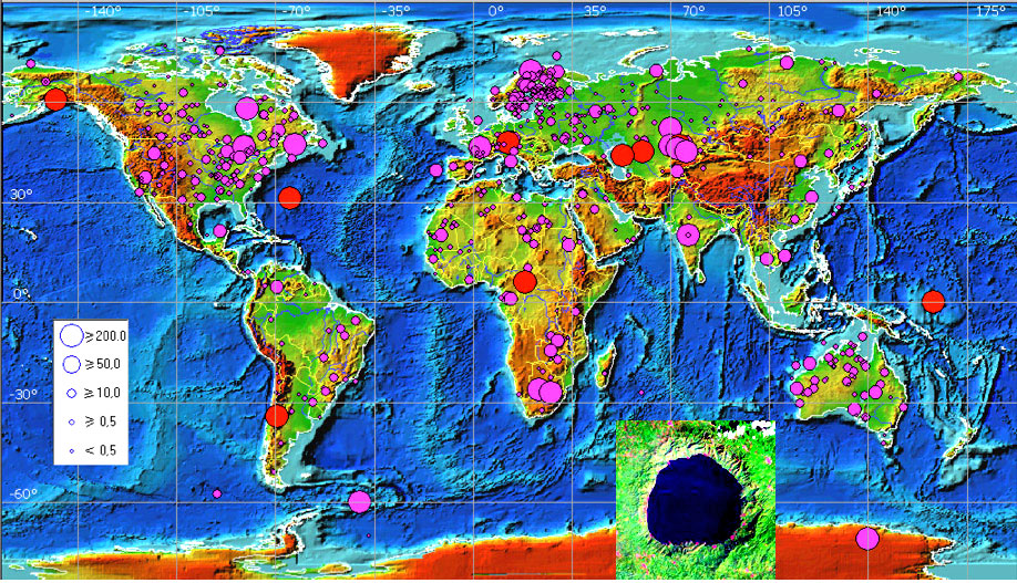
I’m talking about waves hundreds or even “thousands of feet tall” at their max height. Again, if all the “mountains” before the Flood were covered with water there would be no dry land except for fairly short periods of time when a tsunami was coming (which would pull the water from a place before it arrived). Remember also, before the Flood there were no great oceans or continents as we have today. There were only rivers and shallow seas. The Earth was a fairly flat place compared to today’s world. Such a relatively flat world, when covered with a thousand or so feet of water on average would have easily allowed for massive tsunamis to traverse the entire globe. Yes, lot of energy would have been used up during this process. However, I mention again that there wasn’t just one massive tsunami nor was the Flood a simple symmetrical process (see image below of the known asteroid impact sites around the world; Link). It was indeed complex Flood…

You’ve done a good job of revising your description of the flood events, but you’ve got more work to do. I still see no way that “paleocurrents” in a uniform direction supports a global flood. If anything, the very complex flood that you have now admitted had to be the case would be consistent with a hypothesis of largely random paleocurrents. Post hoc explanations based on uninformed imagination are simply “just so” stories.
What have I revised? Paleocurrents are indeed largely random (from a continent-wide perspective at least) above the Paleozoic and some of the Mesozoic. However, within the Paleozoic in particular there are clear continent-wide paleocurrent patterns. Sure, they aren’t perfectly symmetrical or unidirectional by any means, but the patterns are quite clear in a continent-wide distribution. This is not at all difficult to explain from the perspective of a complex massive Noachian-style Flood. However, such features are very difficult to explain from the perspective of tens or hundreds of millions of years of slow uniformitarian geologic evolution. The same thing is true for dinosaurs being stressed out around the entire globe the entire time and for their body fossils to generally be found in layers above their footprints… not to mention numerous other features of geologic and fossil records that strongly favor a catastrophic model of origins.
Recent Comments by Sean Pitman
After the Flood
Thank you Ariel. Hope you are doing well these days. Miss seeing you down at Loma Linda. Hope you had a Great Thanksgiving!
The Flood
Thank you Colin. Just trying to save lives any way I can. Not everything that the government does or leaders do is “evil” BTW…
The Flood
Only someone who knows the future can make such decisions without being a monster…
Pacific Union College Encouraging Homosexual Marriage?
Where did I “gloss over it”?
Review of “The Naked Emperor” by Pastor Conrad Vine
I fail to see where you have convincingly supported your claim that the GC leadership contributed to the harm of anyone’s personal religious liberties? – given that the GC leadership does not and could not override personal religious liberties in this country, nor substantively change the outcome of those who lost their jobs over various vaccine mandates. That’s just not how it works here in this country. Religious liberties are personally derived. Again, they simply are not based on a corporate or church position, but rely solely upon individual convictions – regardless of what the church may or may not say or do.
Yet, you say, “Who cares if it is written into law”? You should care. Everyone should care. It’s a very important law in this country. The idea that the organized church could have changed vaccine mandates simply isn’t true – particularly given the nature of certain types of jobs dealing with the most vulnerable in society (such as health care workers for example).
Beyond this, the GC Leadership did, in fact, write in support of personal religious convictions on this topic – and there are GC lawyers who have and continue to write personal letters in support of personal religious convictions (even if these personal convictions are at odds with the position of the church on a given topic). Just because the GC leadership also supports the advances of modern medicine doesn’t mean that the GC leadership cannot support individual convictions at the same time. Both are possible. This is not an inconsistency.


